今回はIELTS Wring Task 1 Map(地図)問題の書き方と表現について説明します。
地図問題とは、都市(公園や病院などの公共施設も含む)の移り変わりや変化をリポートする形式の問題です。
地図問題の概要
タスク1は、図表の説明です。7-8割以上の確率で「グラフ問題」が出題されます。
これは捉え方を変えると、地図問題またはプロセスのいずれかの問題が、2-3割程度の確率で出題されるということです。
一発で、IELTSの目標スコアに到達する方はほとんどいないため、何度か受験をしていると必ず当たります。
10年前に、地図問題が出題される事はほとんどなかったことを考えると、飛躍的に出題の確率が上昇しています。
また、地図問題は、通常のグラフとは違う表現を使用する必要があるので、個別の対策が必要です!
▮ 地図の種類
地図問題は、三つの設問種類があります。
● 2つの地図 : 過去と現在の地図の比較
● 2つの地図 : 現在と未来の地図の比較
● 1つの地図 : 現在の地図
最も出題されやすいのは、過去と現在の地図の比較です。
以下のような地図です。
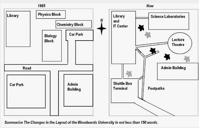
The maps show the changed of Woodwards University spatial during 1985 until now.
左側が過去のWoodwards University、右側が現在のWoodwards University となっています。
パっと見ただけでも、街が大きく変化していることが確認できますね。
また、徐々に出題が増えている印象があるのは「現在と未来の地図の比較」です。
このパターンは、主に都市開発についての設問であることが多いです。
地図問題の書き方と表現
- 地図問題独特の表現を使用する
- 過去形を主に使用する
- 受動態を多く使用する
その他の図表問題と比べて、地図問題の表現は独特です。地図の「位置、方向性、変化」などは、確実に表現できるようにしておきましょう。
基本的に、地図問題は、過去形と受動態を中心に展開する問題です。ですので、この二つの文法項目は使いこなせるようにしておきましょう。
過去形や受動態を使用する理由は、地図内の都市や街の変化を表すためです。都市や街は、人ではないため受動態を、そして、変化はすでに起こった出来事なので過去形を使用します。
未来の地図が出てきた時のみ「未来完了形」を活用して表現します。
▮ 段落と内部構成
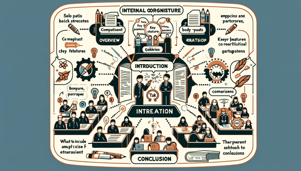
次に、地図問題の段落構成です。段落構成に関しては、その他の設問タイプと同じです。
つまり、4つのパラグラフで構成します :
Paraphrase Sentence(導入): 1文
Overview(概要): 1-2文
Detail 1 (詳細): 3文以上
Detail 2 (詳細): 3文以上
内部構成に関しても、その他の図表と同様の構成です。
導入
1文目- 質問のパラフレーズ
概要
1文目- 大きな変化1
2文目- 大きな変化2
詳細
1文目- 大きな変化1の詳細
2文目- 大きな変化1の詳細
3文目- 大きな変化1の詳細
詳細
1文目 – 大きな変化2の詳細
2文目 – 大きな変化2の詳細
3文目 – 大きな変化2の詳細
▮ 方向性を説明する際に役立つ表現とその例文
地図上の物体や建物の位置関係を正確に説明できます。IELTS Writing Task 1の地図問題では、これらの表現を活用して、変化や配置の違いを明確に伝えることが重要です。
● North of – 「…の北に」
The library is located north of the main entrance.
● South of – 「…の南に」
The parking lot is situated south of the sports centre.
● East of – 「…の東に」
The student accommodation is found east of the cafeteria.
● West of – 「…の西に」
The science building is west of the library.
● Adjacent to – 「…に隣接して」
The swimming pool is adjacent to the gym.
● Directly across from – 「…の真向かいに」
The art gallery is directly across from the main square.
● To the north/south/east/west of – 「…の北/南/東/西に」
The tennis courts are to the east of the football field.
● Between…and… – 「…と…の間に」
The coffee shop is located between the bookstore and the library.
● In front of – 「…の前に」
There is a bus stop in front of the entrance.
● Behind – 「…の後ろに」
The bicycle parking is behind the main building.
▮ 街や都市の変化を説明する際に役立つ動詞とその使用例
これらの動詞はエリア、ビル、木、工場、施設などに関連する変化を示すために使われます。
● Expand (拡大する)
“The industrial area expanded to include a new manufacturing plant.”
● Develop (開発する)
“A new residential development was constructed on the outskirts of the city.”
● Transform (変形する)
“The old factory was transformed into luxury apartments.”
● Renovate (改修する)
“The city hall was renovated to restore its historical appearance.”
● Rebuild (再建する)
“The community center, damaged by the storm, was completely rebuilt.”
● Demolish (解体する)
“Several dilapidated buildings were demolished to improve city safety.”
● Restore (復元する)
“The ancient ruins were carefully restored for public viewing.”
● Modernize (近代化する)
“The school’s facilities were modernized to support new educational technologies.”
● Clear (撤去する)
“The land was cleared of trees to make room for the new park.”
● Plant (植える)
“Hundreds of new trees were planted along the city streets.”
● Erect (建設する)
“A new monument was erected in the city square to honor veterans.”
● Upgrade (アップグレードする)
“The airport’s runways were upgraded to accommodate larger aircraft.”
● Convert (転換する)
“The old warehouse was converted into a modern art gallery.”
● Enlarge (拡大する)
“The parking lot was enlarged to reduce congestion during peak hours.”
● Beautify (美化する)
“The riverbank was beautified with the addition of walking paths and gardens.”
● Pave (舗装する)
“New roads were paved to improve access to the remote areas.”
● Relocate (移転する)
“The zoo was relocated to a larger, more natural environment outside the city.”
● Refurbish (改装する)
“The old theater was refurbished, including new seating and lighting.”
● Construct (建設する)
“A new bridge was constructed to ease traffic between the city and the suburbs.”
● Excavate (掘る)
“Archaeologists excavated the site, uncovering a previously unknown historical settlement.”
解答例
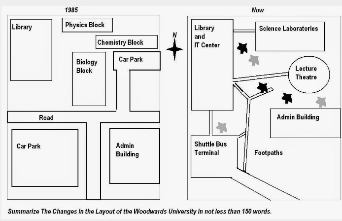
The Woodwards University’s map portrays the changes from 1985 until now. The most significant change is the demolition of many buildings over 20 years. It can be seen the transformation of some buildings with open-space.
First of all, the Woodwards University replaced the largest car park with a shuttle bus terminal and there was no car park anymore.The small car park was altered to be the lecture theatre between the science libraries and admin building. In addition to this, the road was change into shuttle bus line which connected to all buildings except the farthest, science laboratories and passes by admin building.
There have also combined some buildings. Physics block, chemistry block and biology block in the north east became science laboratories behind the lecture theatre. A library which had been opposite the biggest car park in the past was extended and joined with the IT center which now was in front of the shuttle bus terminal.
Finally, admin building which has large building in 1980 has also altered to be long building in the east. Moreover, the remnants of space was built open-space, such as footpaths. (187 words )


